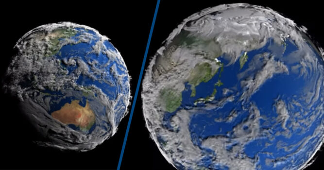

Images of Earth from space largely look the same; a blue ball with patches of green land. However, a new timelapse video from NASA illustrates our planet like a living creature.
The Scientific Visualisation Studio (SVS) at NASA has outdone itself with a seven-day timelapse of Earth, that shows our home in a brand new way. By using data from NASA’s Goddard Earth Observing System Model, Version 5 (GEOS-5), the team managed to use the data to visualise the Earth.
The team used a simulation for the clouds called 7km GEOS-5 Nature Run (7km-G5NR), and it required a supercomputer to process the large and complex data.
The video below showcases the result of the seven-day timelapse:
The SVS has explained on its website that the hard work and processing of a terabyte of brick map files has been done to give people an insight to Earth:
The SVS works closely with scientists in the creation of visualizations, animations, and images in order to promote a greater understanding of Earth and space science research activities at Goddard Space Flight Center and within the NASA research community.
Seeing Earth in this new light will likely interest a lot of people who will be keen to understand how the cloud formations move and interact with the atmosphere. In this instance, it clearly shows a category-4 typhoon developing off the coast of China, and these kinds of activities will undoubtedly excite people who are interested in Earth as well as space.
It seems that SVS is succeeding in its goal to promote a great understanding of Earth and Space, and this video will likely gain the division more fans.